What happens to Community Science Data?

A boreal toad is examined and measured for our boreal toad project. Photo: Kayleigh Mullen and Mary Pendergast
The need for community scientists
Community science—also called citizen science—has been on the rise in recent years. Government agencies, nonprofits, and universities alike rely on community members for all kinds of projects. From monitoring urban birds to classifying galaxies, the work these lay scientists do spans fields and locations. So why are they so important?
To answer scientific questions, scientists need data, or information they can analyze and interpret to make sense of the world. A seismologist might make calculations from a collection of earthquake measurements to understand how these events move through different types of geological materials. A climatologist might examine tree rings to validate weather patterns in a certain area. And in the case of conservation ecology (what we do at Sageland Collaborative), ecologists need information about wildlife and habitats to learn how species are doing and support land managers in planning for future ecological health.
However, sometimes the sheer volume of information needed to examine large questions is impossible for a single researcher to access and process. This is where trained community scientists come in. “Crowd-sourcing” science provides a larger data set for scientists to use in answering crucial questions. Analysis can then be more precise and wide-ranging. In the work we do, this allows for better outcomes for local wildlife and habitats.
What conservation community scientists do
What do our volunteer community scientists do? A little bit of everything!
On our Plants and Pollinators project, community scientists steward a monarch site or use an app to record sightings of bumblebees, monarchs, and milkweed in neighborhoods and on trails. Bird feeders across the West are monitored for our Rosy-Finch Project. And on our Wasatch Wildlife Watch project, volunteers hike hundreds of miles to set up and monitor wildlife cameras.
If you’ve volunteered on one of these or our other projects, you may have wondered what happens to your data.

Community scientists work across the landscape, from measuring stream health in rural areas to monitoring wildfire smoke in a city. Photo: Sarah Woodbury
What happens to community science data?
Working closely with diverse partners, we use your data to learn more about wildlife populations and habitats and make recommendations for their management. This information allows us and our partners to examine regional issues and create informed solutions to ecological challenges. This works slightly differently for each project.
Rosy-Finch Project
Rosy-finches are incredibly mysterious birds. With key habitats in difficult-to-access alpine terrain, these birds have largely evaded scientific understanding. At the same time, the intensified impacts of climate change on sensitive alpine environments endangers the diversity of life that colors these unique ecosystems.

Volunteers who have been lucky enough to spot banded birds, like this pink-banded Gray-crowned Rosy-Finch, have allowed scientists and managers to learn about these mysterious species. Photo: Janice Gardner
Our trained Rosy-Finch Project Volunteers take 20-minute bird counts at feeders from Oregon to Nevada, noting any rosy-finches they see. These bird counts are used in several ways:
Data are shared to the Cornell Lab of Ornithology to inform eBird's range and movement maps.
Many lucky volunteers have re-sighted the project’s color-banded birds, which is helping us understand how rosy-finches are moving between summer and winter ranges.
Data will also be used to create state Wildlife Action Plans, which outline where rosy-finches are and how to best conserve them.
An upcoming publication including this data will describe winter habitat and population estimates.
Impact
Rosy-finches are notoriously difficult to study because of the rugged habitat they nest in and their nomadic tendencies. Having hundreds of extra eyes on the landscape is one of the few methods we have to effectively research these birds. This winter alone, we counted thousands of rosy-finches at hundreds of sites, which otherwise would have been a secret.
Volunteers should be proud they are part of a unique group of people that care about rosy-finches. Volunteers have helped fill in the map on where rosy-finches are and are not (which is important too!). These actions are critical in supporting effective management and action plans for this mysterious species. Partly because of the impressive volunteer participation in feeder counts, biologists and researchers across the West are highly motivated to find collaborative solutions to ensure rosy-finch populations can persist.
Wasatch Wildlife Watch
On our Wasatch Wildlife Watch project, community scientists both manage wildlife cameras and sort the wildlife images captured. This information has been instrumental to:
Many scientific publications exploring fundamental ecological questions, e.g., How do different forms of human disturbance on the landscape influence how native mammal communities use habitats in the Wasatch?
Mapping tools to help scientists and managers understand where habitats are functioning for wildlife and where habitat connectivity may be maintained or improved.
As growth in the Wasatch and entire western region skyrockets, answering questions about human-wildlife overlap is central to ensuring we don’t lose the wildlife and habitats we love most.
Impact
Without the support of community scientists, Sageland Collaborative and our partner at the University of Utah Biodiversity and Conservation Ecology Lab could not gather the long-term, large-scale data required to understand wildlife habitat use patterns. Over 2,345 camera stations have been maintained to date.

A (blonde!) brown bear image captured on our Wasatch Wildlife Watch project. Volunteers set up cameras and analyze project images to support large-scale species mapping and conservation. Photo: Wasatch Wildlife Watch
In addition, our volunteers can be proud that Wasatch Wildlife Watch is the largest contributor of data to the Urban Wildlife Information Network, which works to understand how wildlife occupy and adapt to urban environments and currently spans 40 cities, 4 countries, and 3 continents. The project is also among the largest contributors to Snapshot USA, a Worldwide Annual Mammal Survey and the largest camera trapping project on the planet.
Photo analysis of over 40,000 wildlife detections—and many more to come as 2021 and 2022 data are downloaded for analysis—is extremely time-intensive. Volunteer support is the backbone of this massive project, allowing us to analyze these data for patterns in wildlife habitat use quickly in the face of oncoming threats to local populations.
Utah Pollinator Pursuit
Trained community scientists on Utah Pollinator Pursuit gather pollinator and habitat information using the Survey123 app. Whether they’re recording a neighbor’s flashy milkweed patch, a fat bumblebee on the trail, or a tiny, ribbed monarch egg, they are adding data points to the larger map of pollinator health in Utah. These data are directly processed by:
Going directly into a georeferenced dataset, or a dataset where images of pollinators and plants are associated with the locations the photos were taken on the landscape, hosted directly by the State of Utah.
Utah State University rare insect and plant conservation scientists working with the Division of Wildlife Resources to monitor and review data points as they are added.
Impact
These pollinator observations and habitat assessments for Utah are only possible because of the power of community scientists. With the work of volunteers across the state, managers can better identify areas for pollinator habitat maintenance and restoration. A fuller grasp of how pollinators are currently using Utah for seasonal movement means more targeted conservation actions.
As pollinator populations face huge global declines, knowing where populations are and how they move allows scientists to make recommendations for future conservation projects and development decisions.

Conservation Ecologist Mary Pendergast leads volunteers during an amphibian bioblitz in a Utah canyon.
Boreal Toad Project
Our Boreal Toad Project volunteers are trained to identify boreal toads in every life stage, as well as to monitor habitat health. They travel to mountain sites to search for and document boreal toad and habitat information. Boreal toads face many threats from climate change to a deadly fungus, so understanding their populations is key to supporting their future well-being.
Boreal toad observations, population monitoring, and habitat assessment data gathered by community scientists are:
Entered into a state-wide database,
Which is then accessed by the Utah Division of Wildlife Resources and other committed members of the Boreal Toad Conservation Science Team. These partners are currently working to update the State Boreal Toad Conservation Agreement.
Impact
As with the other projects, this work rests on the deep and continued commitment of community scientists. Monitoring boreal toad populations and assessing aquatic habitat conditions for amphibians at this scale and speed quickens and improves planning for conservation actions. Wildlife and land managers can better pinpoint efforts that will increase the resiliency of amphibians and their habitats.
Without reliable information about sensitive species like boreal toads, decisions on how to best plan for them are made in the dark. Our community scientist data adds more and more light to the room where these decisions are made, illuminating better paths forward.
Stream & Riparian Restoration
It’s no secret that new, rigorous scientific knowledge takes time. Given the urgency of drought and river habitat loss, our Stream Restoration program allows volunteers to act now to support these habitats while also generating useful data. With careful planning, new scientific understanding can be co-produced with on-the-ground restoration.
The program is supported by—and contributes to—a growing body of scientific research understanding the role of beaver reintroduction and other Low-Tech Process-Based Restoration techniques on river habitat for wildlife and people alike. Much of this research has been pioneered in Utah (see Utah State University’s low-tech resources webpage and handbook).
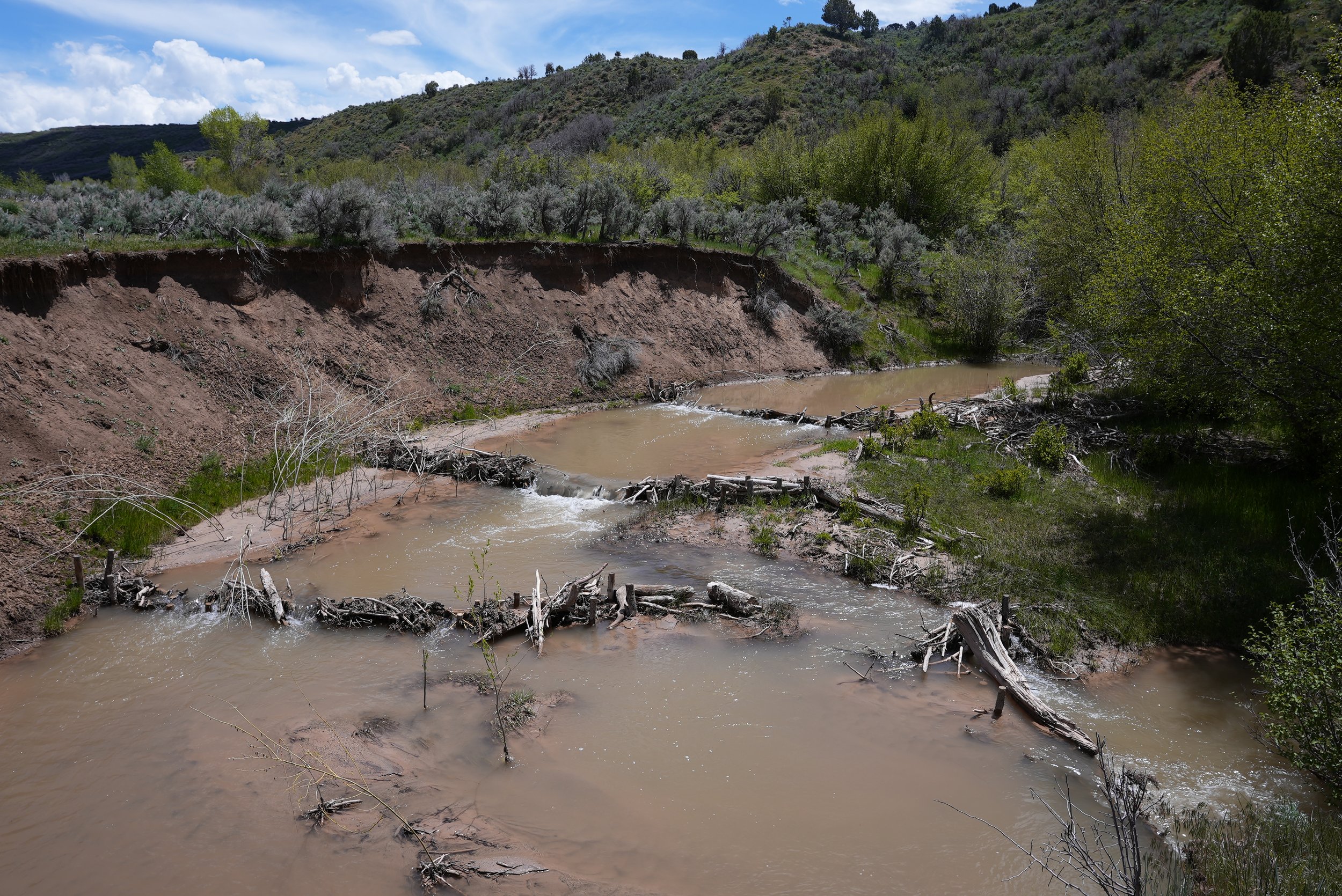
Beaver dam analogues built by volunteers on a degraded Utah stream. If you look closely, you can see willow plantings, also done by our volunteers! These changes support the habitat’s return to a healthier state in the absence of beaver. Beaver have been extirpated from many areas in the West, and as a result, many streams and riparian habitats are unhealthy. Photo: Sarah Woodbury
Our staff and partners monitor all restoration sites with the Rapid Stream-Riparian Assessment Protocol to evaluate habitat improvement following installation of beaver dam analogs. In addition, these sites have been used in the following ways:
Some of our sites serve as in-depth research sites for university partners. These include Marshall Wolf's experiments comparing BDAs to control sites.
Sarah Hinshaw at Colorado State sampled our sites as part of a study on carbon sequestration following different restoration methods across the West.
Lily Bosworth performed undergraduate research at Fish Creek on hydrologic effects of beaver dam analogues and has a paper forthcoming.
In addition, note that on our stream restoration days, it’s not uncommon to find volunteers taking a moment to record a bumblebee or toad for our other projects!

Communications Director Sarah Woodbury excitedly takes toad measurements for our boreal toad project. Photo: Alex Baldwin.
Impact
Your hard work restoring riverscapes in our communities is changing the culture of restoration in Utah and the western United States. There is a growing recognition by landowners, municipalities, funders, and administrative agencies of the multitude of benefits that healthy riverscapes provide. Your success stories from these sites have reached landowners and stakeholders across Utah and beyond.
More community science impact…
Beyond the listed impacts on our projects, community science has another core impact: it creates and reinforces relationships between humans and the land, wildlife, and communities that surround them. Our dedicated volunteers inspire us to continue striving for the best conservation outcomes we can make possible. A huge thank you to all you community scientists and donors!
Get involved in community science in the West
Are you ready to join our amazing group of volunteers answering conservation questions for wildlife conservation? Check out our current projects or donate today to make more of this work possible!

Project lead Austin Green trains Wasatch Wildlife Watch volunteers on how to set up and monitor wildlife cameras across the Wasatch. These images are used to map important wildlife migration data and support conservation planning in the region.
Author: Sarah Woodbury